After a light, picturesque snow last night, things get nasty this weekend.
LITTLE CHANGE TO THE FORECAST, WINTRY KITCHEN SINK SUNDAY
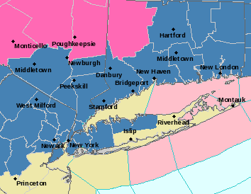
A weak system brought an inch or so of snow to Long Island last night into this morning. While skies have remained mostly cloudy, there have been some breaks of sun today, enough to melt most of what was on the ground. So we will be starting fresh come tomorrow night. Winter storm warnings have been issued for Nassau and western Suffolk, shown below in blue:

If you have any travel plans on Saturday, you are okay up until about 4 or 5pm. The leading edge of our storm arrives, and will bring a ‘thump’ of heavy snow as we head into Saturday night. This could lead to some quick, plowable accumulations (1-3″, a few locally higher numbers not out of the question)

As we head into Saturday morning, rising temperatures will change this over to rain for most of the island. Winds will become gusty as well, perhaps leading to some minor coastal flooding. There are certain spots of the north shore that may take longer to change or go over to sleet or freezing rain for a while, prolonging accumulations and causing icy spots. This rain will be heavy (1-2″) and with such a juicy storm, some dynamic cooling is not out of the question, nor is some thundersnow! There have been some models that have trended warmer this afternoon, but I am sticking with my forecast for now.
As we continue into Sunday afternoon, temps will quickly begin to plummet. As this occurs, we could see some freezing rain and icy conditions before maybe a quick change back to snow on the back edge of the storm – maybe we pick up another inch or so. But my concern is squarely on the ice situation. This temperature crash or ‘flash freeze’ will cause black ice from any standing liquid as we head into Sunday night. Temperatures will fall into the teens and single digits, with wind chills below zero! That is some dangerous cold headed our way.
We have a total lunar eclipse on Sunday night, beginning around 10:30 and peaking about 20 minutes after midnight. If you are planning on going out to see it, skies will have cleared, but it will be absolutely frigid. Maybe only plan on peaking out around midnight, and dress in your warmest winter gear!
Thanks for visiting WeatherLongIsland.com. Did you enjoy this article? Make sure to bookmark the page. And don’t forget to follow Meteorologists Geoff Bansen & Joe Cioffi on social media as well!
Geoff: Facebook Twitter Instagram
Joe: Facebook Twitter Instagram


