
Long Island About to Be Slammed Again
Heavy Rain, Strong Winds Coastal Flooding Friday Night into Saturday
 USE COUPON CODE IWANTAWEATHERSTATION GET 10 PERCENT OFF ANY PURCHASE

Long Island About to Be Slammed Again
Heavy Rain, Strong Winds Coastal Flooding Friday Night into Saturday
One major storm is hard enough but when you get two in one week and 3 days apart, that is really difficult to deal with. Another powerful major storm is set to develop in the Southern Plains and head for the Great Lakes. This storm is almost identical with the one we just experienced. Once again we have we are going to deal with heavy rain, strong winds, and coastal flooding. The coastal flooding issue will be perhaps a bit worse this time around because we have a new moon Thursday and coming into peak tides Friday.
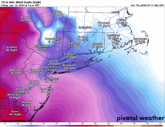
First off the winds will be gusting to 40 mph or higher along the coast and some models are forecasting potential peak gusts over 50 to 60 mph. It isn’t guaranteed that we will see those high numbers but everything has been compromised by Tuesday night’s vicious storm so it may not take much to bring trees and power lines down. Let’s hope for a better outcome but we cannot dismiss the possibility.
SATELLITE

WEATHER RADAR


Meanwhile today we see no weather issues as it will be a calm Thursday. We should be no worse than partly sunny today with afternoon highs in the mild upper 40s to around 50. Skies tonight should be clear with most lows in the 30s. Friday look for increasing clouds and also winds will start picking up again from the southeast. Low pressure will be heading from the Southern Plains to the Great Lakes and intensifying rapidly.

Friday night will be rough with windswept heavy rain and the risk for a thunderstorm or two. Winds will be gusting 40 to 50 mph or higher at times into Saturday morning. Temperatures will likley rise through the 50s and into the low 60s in some places. The front will pass offshore Saturday morning plus or minus an hour or two of day break.

The fast movement of the system will likely hold the rain down but it will still be every bit of an inch to an inch and a quarter. Once again the biggest issue for the immediate coast will be coastal flooding. We will be coming off a new moon and peak tides are Friday. Expect Coastal Flood Watches and Warnings to be posted for Long Island for high tide and moderate to possibly major coastal flooding. Saturday itself will be windy with temperatures falling as we go through the day along with clouds and some sun. Temperatures will settle in the 40s and then down into the lower 20s Sunday morning. Sunday will be cold with some sunshine and a gusty breeze. Highs will just be in the lower 30s.
BE SURE TO DOWNLOAD THE FREE METEOROLOGIST JOE CIOFFI WEATHER APP &
ANGRY BEN’S FREE WEATHER APP “THE ANGRY WEATHERMAN!
MANY THANKS TO TROPICAL TIDBITS FOR THE USE OF MAPS
Please note that with regards to any severe weather, tropical storms, or hurricanes, should a storm be threatening, please consult your local National Weather Service office or your local government officials about what action you should be taking to protect life and property.
