Long Island Severe Weather Threat
Long Island Severe Weather Threat
Latest HRRR Model Analysis
Determining a Long Island Severe Weather Threat is going to be a little tricky. Areas from New York City south and west are clearing in the warm tropical air. A weather front has set up across Long Island which is keeping things cooler thanks to the marine influence. In the spring this kills thunderstorms. The question is whether the upper air dynamics today will compensate for that. Also there is a chance the warm front moves northward this afternoon and evening which will open the door for thunderstorms to move across Long Island later this evening.
Long Island Severe Weather Threat Video Analysis
[brid video=”52486″ player=”6390″ title=”Severe Weather Threat Friday July 8th 2016″]Current Long Island temperatures are in the 70s thanks to a northeast wind. We will have to watch and see if the warm tropical air comes back in this afternoon.
CITY           SKY/WX    TMP DP  RH WIND       PRES   REMARKS
CENTRAL PARK   SUNNY     83  70  64 NE8       29.82R
LAGUARDIA APRT MOSUNNY   82  71  69 NE13      29.79R
KENNEDY INTL   MOSUNNY   85  70  60 VRB7      29.80R
NEWARK/LIBERTY MOSUNNY   87  69  54 VRB3      29.78S HX  91
BRNX BOT. GARD   N/A     81  70  69 NE1       29.81R
TETERBORO      SUNNY     86  70  58 VRB5      29.78S HX  90
$$

NYZ177-179-078>081-081600-
LONG ISLAND NEW YORK

CITY           SKY/WX    TMP DP  RH WIND       PRES   REMARKS
FARMINGDALE    CLOUDY    78  72  81 NE9       29.81R
ISLIP          CLOUDY    78  71  79 NE12      29.80R
SHIRLEY        CLOUDY    77  72  84 E3        29.82R
RIVERHEAD        N/A     73  70  88 E2        29.81R
WESTHAMPTON    CLOUDY    72  68  87 VRB6      29.83R
SOUTHAMPTON      N/A     73  70  88 NE8       29.78R
BRIDGEHAMPTON    N/A     72  68  88 E3        29.67R
EAST HAMPTON   CLOUDY    69  65  85 NE12G17   29.83R
MONTAUK POINT    N/A     69  64  84 NE9G18    29.84R
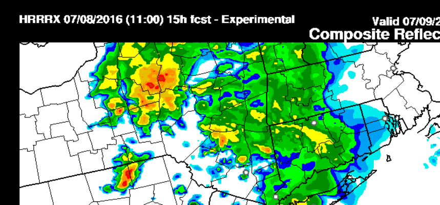
The HRRR model has thunderstorms moving through this evening between 8pm and 10pm and actually holds the line together rather impressively.
Long Island Severe Weather Threat HRRR MODEL 8PM
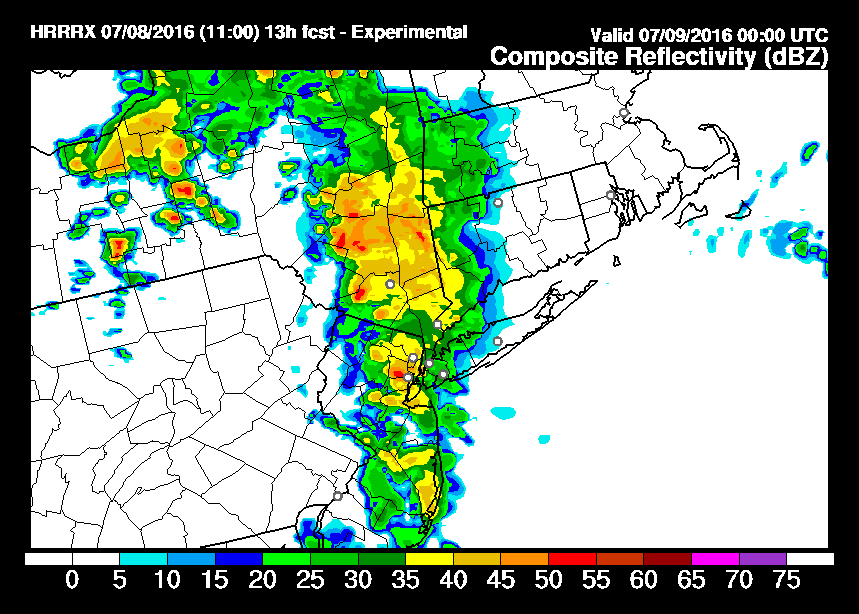
Long Island Severe Weather Threat HRRR MODEL 10PM

Check the latest radar and satellite and other HRRR model views at meteorologistjoecioffi.com
FiOS1 News Weather Forecast For Long Island
FiOS1 News Weather Forecast For New Jersey
FiOS1 News Weather Forecast For Hudson Valley
NATIONAL WEATHER SERVICE SNOW FORECASTS
LATEST JOESTRADAMUS ON THE LONG RANGE
Weather App

Don’t be without Meteorologist Joe Cioffi’s weather app. It is really a meteorologist app because you get my forecasts and my analysis and not some automated computer generated forecast based on the GFS model. This is why your app forecast changes every 6 hours. It is model driven with no human input at all. It gives you an icon, a temperature and no insight whatsoever.
It is a complete weather app to suit your forecast needs. All the weather information you need is right on your phone. Android or I-phone, use it to keep track of all the latest weather information and forecasts. This weather app is also free of advertising so you don’t have to worry about security issues with your device. An accurate forecast and no worries that your device is being compromised.
Use it in conjunction with my website and my facebook and twitter and you have complete weather coverage of all the latest weather and the long range outlook. The website has been redone and upgraded. Its easy to use and everything is archived so you can see how well Joe does or doesn’t do when it comes to forecasts and outlooks.
Just click on the google play button or the apple store button on the sidebar for my app which is on My Weather Concierge. Download the app for free. Subscribe to my forecasts on an ad free environment for just 99 cents a month.
Get my forecasts in the palm of your hand for less than the cost of a cup of Joe!
