Blizzard Watch Coastal Flood Watch Posted
Blizzard Watch Coastal Flood Watch Posted
Blizzard watch is posted for Long Island for late Monday night into Tuesday evening as a major winter storm strengthens off the Virginia coast and heads northeast. These are the hazards we are expecting
SNOW: ACCUMULATIONS OF UP TO 12 INCHES. AMOUNTS WILL DEPEND ON WHETHER MIXING OR A CHANGE TO RAIN TAKES PLACE
WIND: STRONG WINDS GUSTING TO 50-60 MPH WILL OCCUR DURING MONDAY AS THE STORM NEARS
COASTAL FLOOD WATCH FOR THE HIGH TIDES ON TUESDAY WITH MODERATE COASTAL FLOODING
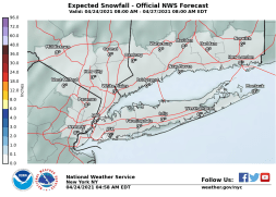
Right now my snow forecast is on the low end of the National Weather Service estimates of 12 to 18 inches. I think that 12 inches is possible especially in Northwest Suffolk and most of Nassau County with a little less as you go east but this will hinge on any change to sleet or rain for a few hours. Sometimes even the change to rain doesn’t prevent the high end accumulations from occurring since it will change back later in the day. This part of the equation will be evaluated probably as we move through the event. National Weather Service snow forecasts are below.
NEW YORK CITY AND VICINITY SNOW

NEW YORK CITY & VICINITY ICE
NEW JERSEY & PARTS OF NE PA
Strong winds will be an issue here during Monday as the storm center passes close to the East End of Long Island. Wind gusts of 50-60 mph are likely and that could cause some tree damage and downing of power lines. Coastal flooding at high tide is going to be an issue with Sunday’s full moon. Spring tides are already running high and the addition of this noreaster introduces moderate coastal flooding at high tide Monday night and on Tuesday. 2 high tide cycles seem to be in play here.
..COASTAL FLOOD WATCH IN EFFECT TUESDAY MORNING...

THE NATIONAL WEATHER SERVICE IN UPTON HAS ISSUED A COASTAL FLOOD
WATCH, WHICH IS IN EFFECT TUESDAY MORNING.

* LOCATIONS...THE SOUTH SHORE BAYS OF LONG ISLAND AND THE LOWER
  NEW YORK HARBOR.

* TIDAL DEPARTURES...2 TO 3 FT ABOVE ASTRONOMICAL TIDES.

* TIMING...AROUND THE TIME OF TUESDAY`S HIGH TIDES.

* IMPACTS...WIDESPREAD FLOODING OF VULNERABLE SHORE ROADS AND/OR
  BASEMENTS DUE TO HEIGHT OF STORM TIDE AND/OR WAVE ACTION.
  NUMEROUS ROAD CLOSURES POSSIBLE.

PRECAUTIONARY/PREPAREDNESS ACTIONS...

A COASTAL FLOOD WATCH MEANS THAT CONDITIONS FAVORABLE FOR
FLOODING ARE EXPECTED TO DEVELOP. COASTAL RESIDENTS SHOULD BE
ALERT FOR LATER STATEMENTS OR WARNINGS...AND TAKE ACTION TO
PROTECT PROPERTY.
We will be monitoring weather model runs for clues on whether cold air will be more important and keeping precipitation mostly frozen. Here is my snow forecast map for Long Island for the moment at least. If there is no change to sleet or rain amounts will be higher.


