
After a minor event tonight, Long Island could see each type of precip. thrown our way this weekend.
LIGHT SNOW-RAIN TONIGHT, SUNDAY SHAPING UP TO BE AN ICY MESS
Good afternoon everyone. It has been a bright and sunny start to the day, but clouds are now starting to increase from the west as tonight’s minor event approaches.

Light snow will begin after midnight and last in to Friday morning, when it will either end or briefly mix with rain. Keeping firm with yesterday’s forecast, Long Island can mainly expect a coating to and inch from this weak system. The sun should break out by the afternoon with temperatures around 40°.


Saturday will start with sun but it will fade behind clouds during the afternoon. It will also be colder with temps back down in the 30s. With temperatures down around freezing, any precipitation will begin as snow as our more potent storm arrives Saturday night.
EARLY CALL FORECAST FOR SATURDAY NIGHT INTO SUNDAY MORNING

Areas south and east of the 3-6″ cutoff is where some changeover is likely to occur Sunday morning. For the south shore and east end of Long Island, I am expecting a rather quick changeover to all rain, which would certainly limit totals. However, I am very concerned about icy conditions across central LI and along the north shore.
First, we will look at the GFS, which has remained very consistent over the last few days with a snow-to-rain-to-sleet-or-freezing-rain-back-to-snow solution over the course of this storm. Take a look:
SATURDAY NIGHT
SUNDAY MORNING
SUNDAY AFTERNOON
SUNDAY EVENING
Now the GFS being a global, long-term model means it will have a lower resolution. Enter the NAM which is now in range:

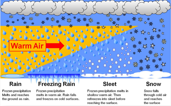
You can more clearly see the differentiation between the areas receiving rain/freezing rain/sleet/snow. As it stands now, Long Island would see snow mostly washed away by the rain, but there could be some dangerous icing conditions with freezing rain. Yes there is a very big difference between sleet and freezing rain. Sleet is a snowflake that melts and refreezes into a tiny ice pellet before it hits the surface. Freezing rain on the other hand is a melted snowflake (or simply a raindrop) that becomes super-cooled so much that it freezes on contact as soon as it hits the surface. While neither is optimal for any kind of travel, the latter can be downright catastrophic. This is why I am so concerned with things the way they look presently.
The cut-off line is very close for each, a mere 20-40 miles would make a huge difference if we were to see a shift in the storm track over the next 24-48 hours. I will continue to monitor this situation closely for you. But as I have been saying, regardless of precipitation type, we are all going to experience a flash freeze Sunday afternoon and evening. Temperatures will crash through the 30s and 20s, bottoming out in the teens and even single digits Sunday night! Black ice from standing water is of big concern. And factoring in some blustery conditions, we are expected to see wind chills below zero heading into Martin Luther King Day.
MLK DAY MORNING TEMPERATURES
Suffice it to say that once Saturday night arrives, going outside will not be pleasant for the next few days! -Geoff
Thanks for visiting WeatherLongIsland.com. Did you enjoy this article? Make sure to bookmark the page. And don’t forget to follow Meteorologists Geoff Bansen & Joe Cioffi on social media as well!
Geoff: Facebook Twitter Instagram
Joe: Facebook Twitter Instagram
